Root Cellar Cave Survey Project
Root Cellar Cave is located in south Texas on private land. It is a small cave with a large root system that extends through much of the cave.
| Data Summary as of August 25, 2007 |
|---|
Number Of Surveys = 1
Number Of Stations = 11
Included Shots = 11
Excluded Shots = 0
Ignored Shots = 0
Number Of Loops = 1
Absolute Stations = 0
|
Included Length = 175.2 Feet (0.03 Miles)
Excluded Length = 0 Feet
Total Surveyed = 175.2 Feet (0.03 Miles)
Horizontal Length = 138.4 Feet (0.03 Miles)
Horizontal Excluded = 0 Feet
Cave Depth = 39.5 Feet
Surface Length = 36.6 Feet
Surface Width = 57.4 Feet
Surface Area = 2102.0 Ft^2
Enclosed Volume = 83,018.5 Ft^3
Cave Volume = 31,190.9 Ft^3
Average Diameter = 13.3 Feet
Volume Density = 37.57 %
Average Inclination = 30.8 Deg.
Difficulty = 29.4
|
Highest Station = A0 (0.0 Feet)
Lowest Station = A3 (-39.5 Feet)
North Station = A0 (0.0 Feet)
South Station = B3 (-57.4 Feet)
East Station = A2 (5.3 Feet)
West Station = B3 (-31.3 Feet)
Average Shot Length = 15.9 Feet
Longest Shot = 38.2 Feet
Shortest Shot = 5.6 Feet
|
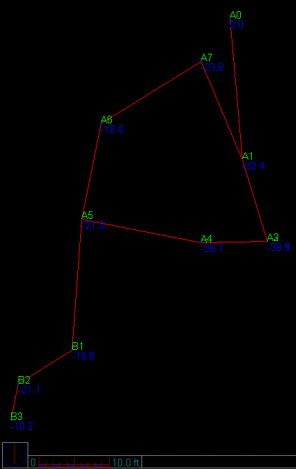
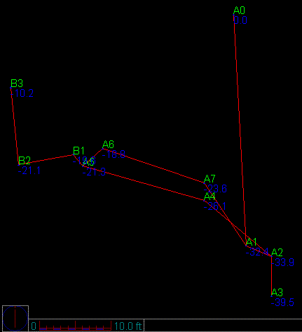
View Line Plot
Plan
Profile
|
|
| Survey Trip 1 |
August 25, 2007 |
| Survey #1 |
|---|
| Instruments: | Dan Dennison, Brian Alger |
| Lead Tape: | Whitney Reynolds, Lee Ann Dean |
| Sketch: | William Tucker |
| Photography: | Tammy Tucker |
| Total Surveyed: 175.2ft |
| Total Time: 5hrs (Survey is complete) |
|
| Top |
ROOT CELLAR CAVE SURVEY LINE PLOT
Plan View |
 |
ROOT CELLAR CAVE SURVEY LINE PLOT
Profile View |
 |
|